Fantasy flights
You’ll need
- Tables
- Chairs
- Big pieces of paper
- CAA topographical air map
- Aviation protractors
- Nautical map ruler
- Projector and screen, optional
Before you begin
- Find some Civil Aviation Authority (CAA) topographical air maps and navigation tools. To borrow the maps, try speaking to members of your group, contacting a local flying club or Air Cadets, or contacting UK Air Scouting. CAA maps are updated every year so you may be able to find out-of-date ones. Alternatively, visit Skyvector to see free online charts.
- Familiarise yourself with headings, tracks, bearings and drift. Flight Club offers some great simple videos on YouTube: watch Track vs Heading to start.
- You may decide you need the help of an expert guest to deliver this session.
- Research local people who are knowledgeable about aviation and plotting flights. Ask group members, people from your local flying club, Air Cadets or Air Scouts.
- Invite someone along to your usual meeting place as a guest.
- Ask the guest about the area of aviation they specialise in, and let them know your plans for the session.
- Give the guest plenty of notice before the session. Check if they need information about access or transport.
- Check in a couple of days before the session that they’re still going to join you. See if they are bringing anything with them, or whether you should provide anything – big sheets or paper and pens or a whiteboard and projector may be useful.
- During the session, introduce the visitor to the group and perhaps ask a few young people to prepare some questions to ask the visitor.
Understand flight tracks
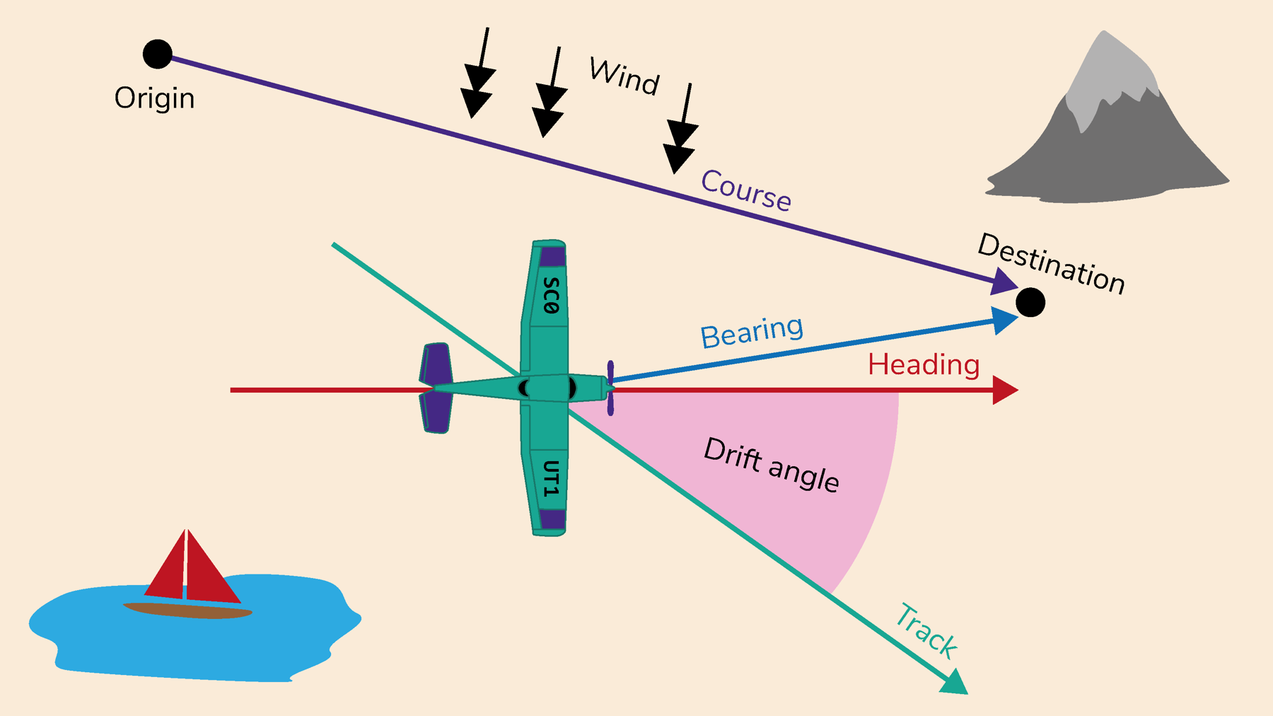
- The person leading the activity should explain that there are four concepts to consider when making a flight plan:
- Headings – the compass direction in which an aircraft’s nose is pointing.
- Tracks – the direction of the aircraft tracking across the ground.
- Bearings – the angle between the start and end of the leg.
- Drift – caused by the weather. Navigators will set a course to steer (using cardinal direction) that compensates for any drift.
- Everyone should get into pairs and sit down with scrap paper, pencils, an air map, a ruler and protractor.
- One person in each pair should draw three headings with corresponding tracks and challenge their partner to calculate the drift in degrees (the angle between the heading and the track).
- Every pair should swap roles and set three more headings and tracks.
Draw your own flight tracks
- Everyone should stay in their pairs and get a CAA topographical air map.
- Every pair should plot an imaginary flight. Choose from these two options:
- Draw a track for a flight of at least 80 nautical miles. Point out the landmarks that would show up on both sides of the track, in clear visibility, at an altitude of about 600 feet.
- Identify landmarks on the map that you would see during a flight of about half an hour in clear weather.
- Every pair should draw a second track, joining two places that are at least 100 nautical miles apart. Measure the exact distance once the track has been drawn.
Reflection
This activity was about trying new things and learning to solve problems. Learning some of the finer details of flight planning can be tricky. Everyone should take time to reflect on the ways they learn best. This way, when it comes to approaching the next new challenge, they can say what works for them.
Safety
All activities must be safely managed. You must complete a thorough risk assessment and take appropriate steps to reduce risk. Use the safety checklist to help you plan and risk assess your activity. Always get approval for the activity, and have suitable supervision and an InTouch process.
You must run your activities in line with the Safeguarding Code of Conduct for Adults (Yellow Card) and report any concerns to the UK HQ Safeguarding Team.
Add more aviation calculations to increase the challenge, including the WCA rule of thumb (wind correction angle calculation). Real flight plans also require you to think of fuel calculations and how to best comply with air traffic control.
- Map work can be modified to make it more tactile. Consider tacking old maps or photocopies up on cork boards and using pins and string to plot the tracks.
- If the detail on your maps is very small, try using magnifying glasses. Online map reading makes it easier to zoom in on finer details.
All Scout activities should be inclusive and accessible.
Consider visiting an airfield or a flight simulator as an additional experience. See Artificial aviation for more information.
Young people control the difficulty of the activity as they set challenges for themselves and one another.